
Land Bank Field Assistant Jacob Wagner chats with SJPT staff at Halvorsen Rd trailhead
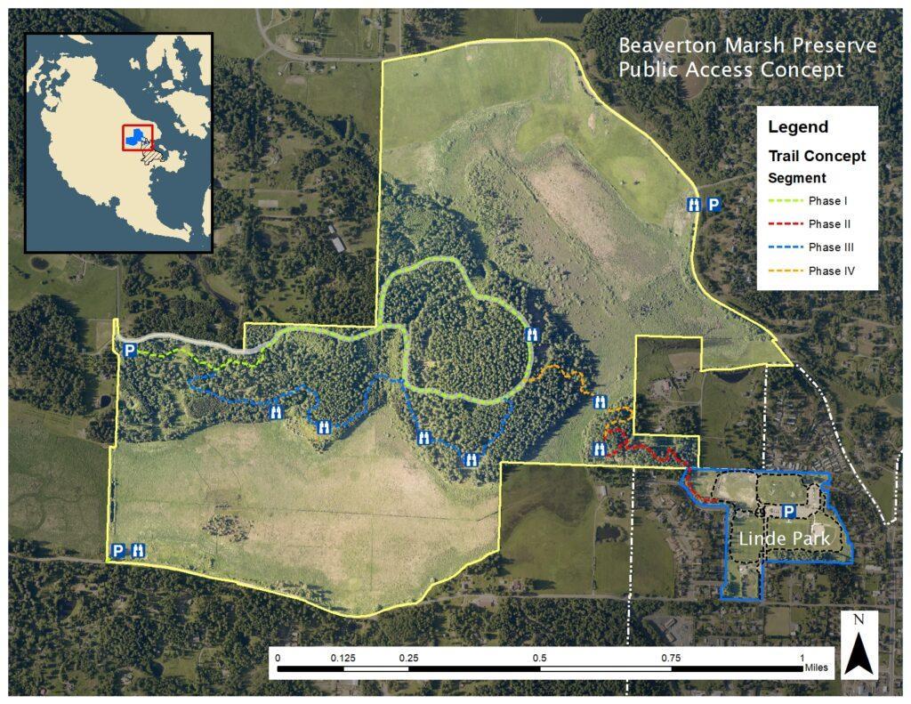
Staff members and volunteers of the San Juan County Conservation Land Bank have been as busy as, well, beavers over the past year as they’ve worked towards opening the first phases of an extensive planned trail system on Beaverton Marsh Preserve. They’ve divided this ambitious concept for public access into four phases (labeled in the concept map, below). Here’s the status of each phase as of late July:
- Phase I: A new trailhead off of Halvorsen Road was opened last fall. It provides access to the Nuthatch Trail—a broad, smoothly graveled multi-use path. It connects the trailhead parking lot with the Dragonfly Trail loop (an improved forest road). Total roundtrip distance: 2.1 miles.
- Phase II: This trail connects John O. Linde Community Park to a vantage point overlooking the marsh. The portion of this trail that lies within the Beaverton Preserve property is nearly complete. Another section of the trail lies within Linde Park, which is managed by Island Rec (the San Juan Island Park and Recreation District). Permitting and bid solicitation for this portion is underway. Assuming permits are received as expected, Phase II is on track for completion this fall.
- Phase III: This rustic, half-mile spur, called the Pintail Trail, connects with the (Phase I) Nuthatch and Dragonfly trails. Traversing forest and mossy balds, it offers multiple viewpoints over Beaverton Marsh. It will be an excellent place to view migratory waterfowl over the winter, including Northern pintail ducks. It opened on July 16.
- Phase IV: In the Land Bank’s Public Access Concept, this is envisioned as a pedestrian path that would cross the marsh at its narrowest point, connecting the Linde Park access trail on the preserve’s southeastern flank with the trails on the western side, accessible from the Halvorson Road trailhead. The marsh crossing, while relatively short, is the most challenging part of the trail system to design and build. To support a boardwalk over the wetland, for example, foundational pin piles would need to be driven 110 to 130 feet down to bedrock. (Nope!) The idea of a simple mown path is being considered, although usable only during the driest part of the year. Even this July, however, after a month-long rainless dry spell, the crossing site was a bit too wet and muddy to support foot traffic. So the search for solutions continues.
Hats off and many thanks to our friends at the Land Bank for all their hard work in making Beaverton Marsh Preserve an amazing asset for public access and enjoyment!
Scroll down to see photos.
The Land Bank’s Public Access Concept map:

20230525-IMG_4237
Trailhead sign on Halvorsen Rd.

Halvorsen trailhead-web
Info kiosk and Nuthatch Trail at Halvorsen Road trailhead

20230525-IMG_4235
Interpretive sign at trailhead kiosk

20230525-IMG_4247
A new trail, named for the Nuthatch, connects with other trails in the network.

20230525-IMG_4239
SJPT staff members on a trail section built by Youth Conservation Corps crews

20230525-IMG_4242
Intersection with the Dragonfly Loop

20230525-IMG_4251
Viewpoint overlooking the marsh

pintail-trail-wcc
WA Conservation Crew members pause for a pose during construction of the Pintail Trail | Courtesy SJC Land Bank

20230525-IMG_4245
Another view over the marsh

20230525-IMG_4250
Construction on Phase II of the Beaverton trail network
